Flightradar24 is a progressive software that allows tracking any plane above the Earth and having an accurate minute information on it and its current and past flights. The tracker can be accessed via the Web or through mobile apps for Android or iOS-powered devices.
The service is based on the data received from the ADS-B receivers placed in different parts of the world. Starting from Scandinavian countries in 2006 as an initiative of two aviation enthusiasts from Sweden, the network developed quickly into the large coverage. However, embracing the globe is still the target to be achieved. Any owner of the ADS-B receiver can feed the system with its data, thus benefiting the wider and more precise information.
Statistics speaks for itself:
![]()
Flight Radar 24 – the milestones of development
The idea to customize the ADS-B receivers data into the tracking system has been first realized by two aviation lovers from Sweden in 2006. At first, only the Scandinavian countries and Central Europe were covered; yet, the network had been growing quickly. In 2009, the service performance has been boosted, while its initiators allowed all ADS-B receiver users connect to the system and thus make a contribution to the network.
A year after, the tracker’s data were used by global media to illustrate the flights’ schedule changes and aircraft movement above Europe and Atlantic during the volcano eruption in Iceland. This has inspired the interest and attracted thousands of users into the service. Today it embraces vast space, though a full global map makes another milestone to reach.
In 2014, the dramatic aircraft catastrophes brought another wave of keen interest to the tracker. When one of the Malaysia Airlines planes’ got missed and another crashed over Ukraine in July 2014, the service’s online map had a powerful boost of visitors. The Indonesian AirAsia aircraft’ disappearance later in the same year triggered another wave of interest to the tracker. The service reported a 50-times increase in users’ visiting, resulting in the temporary online access problems.
Most of the aviation radar feeding stations are created by passionate users. They place the ADS-B receivers at their homes and other locations, where the devices decode the data received from planes and send the information to the Flightradar server via the Internet. By the end of 2015, there were 9,000 receivers registered in the system. By that time, in November, the Guardian published the news about another aircraft catastrophe using it’s data as an official source.
The essence of Flightradar24.com
Primarily based on ADS-B receivers’ data, the Flightradar got developed over the time. Today, it combines the information received by radars and the preciseness of the data is boosted by the MLAT technology implementation. Both aircraft and airport data are used and constantly updated. The combination of the several data feeds allows reflecting the most accurate position of any aircraft. Depending on the destination status (“unknown” / “known”), the plane’s current location is traced within every 10 or 120 minutes. Sometimes, the mistakes happen due to the insufficient coverage or poor connection with the aircraft. Then, the biggest deviation might make a bit more than 80 km.
The following means of tracking connection are used:
ADS-B receivers
This technology relies on transponders installed in each modern (and in some outdated) aircraft. The technology merits made for including it as a primary data feeding means in all aircraft by the year 2020. Currently, less than one-fifth of the general aviation planes is equipped with the ADS-B transponders. For passenger flights, this number is much bigger (about 70% on average), yet, still not enough for providing the full picture of the current aviation.
The ADS-B technology allows each receiver to control the territory of about 322 km around it. It works at the high frequency of 1090 MHz, so the low signal is better caught at the higher flight. Today, there are 17K+ inland ADS-B receivers that receive and transmit the relevant signals from on board. The full coverage is present at the States and for all the European countries. As well, the most of South America and South Africa, Canada, Russia, the Middle East, and most of the Asian major countries (including China and Japan) have a well-established ADS-B connection. There might be some flaws in coverage in other countries; still, the ADS-B receivers’ worldwide system is constantly growing providing the more precise and informative data.
The mechanism of ADS-B-based tracking system goes like follows:

Flarm receivers
Flarm is a technology working for smaller personal aviation. These receivers can catch signals within 96 km and are used mostly by airports with intensive glider traffic.
Multilateration technology
For the planes with the older version of transponders, the position can be calculated basis the MLAT tech. It is based on the data received from four or more receivers and the estimation of the time the signal needs to get through. This mode of data transmission can be used only above 3,000 feet height. Currently, the technology is used over Europe, North and South America, Asia, South Africa, Australia. The data received by means of MLAT is precise though features a bit more delay than ADS-B technology operation.
Radar technology
Flightradar24 is enhancing its data by means of the information got directly from radars. The major part of the commercial flights and scheduled private flights are registered by radars. This technology covers the territory of Canada and the States, as well as adjoining oceans airspace.
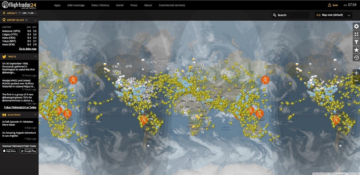
How to go with the Radar 24 Service?
Accessing the website, you can see the map of the air traffic in the real time. To find the information about the specific flight, you can:
- Use the search tab and install filters (some are available with the paid account only):
- Find a specific airport (via Search or clicking on it on the map) and get the information about the flights to and from it. The airport filter can be used (incoming or departing flights can be selected, or both).
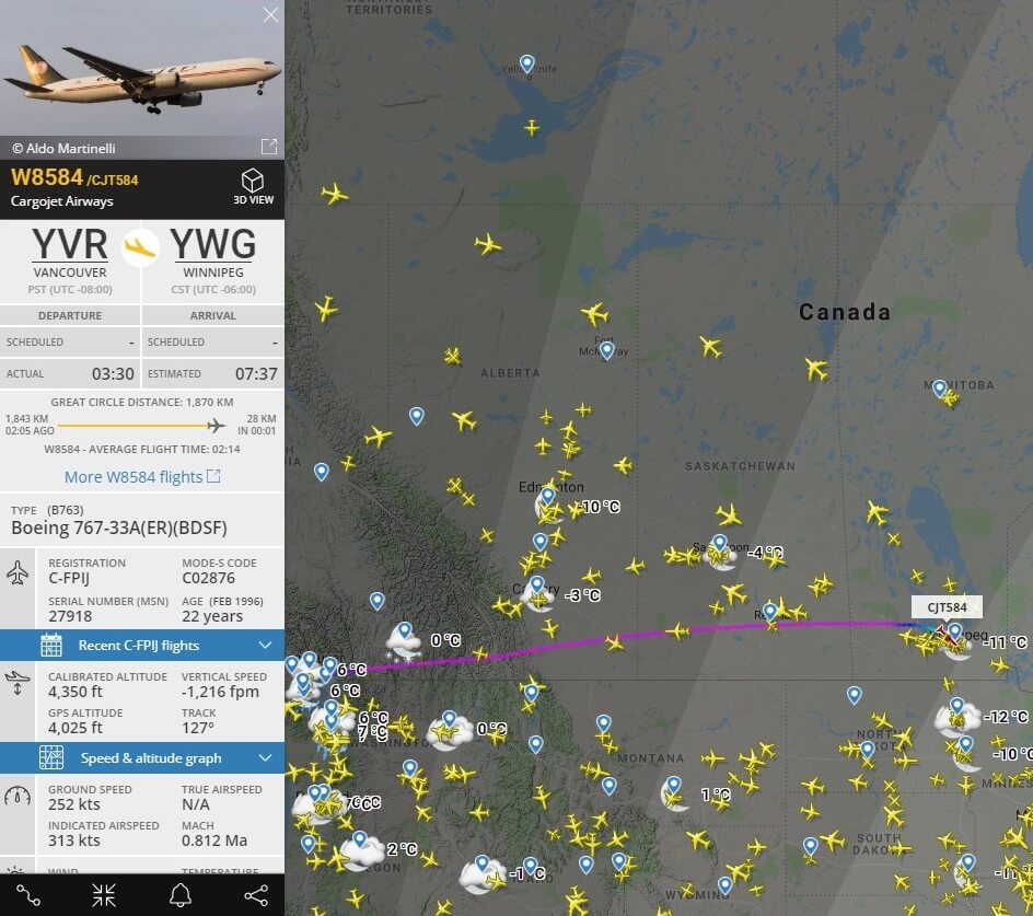
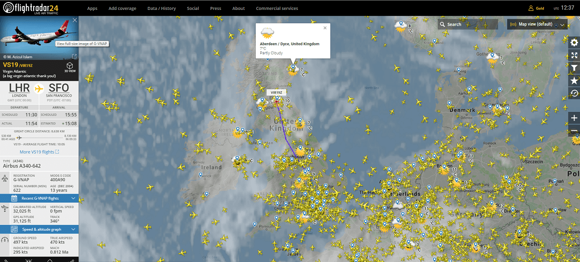
- The cursor hovering over the plane makes for the tail number popping up. When clicking on the plane, you will see the following data in the left part of the map:
The paid account provides for additional information:
Additional options include:
- tracking the route of the specific aircraft (click the icon in the lower left corner)
- the record of the aircraft movement can be viewed (up to one week for free account, up to one year for the paid account). Date, time and speed of record must be set
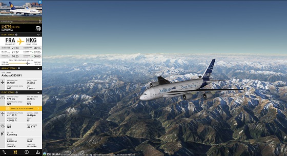
watch the plane flight in 3D (currently available as the beta option) - for the paid account: e-mail notifications / push SMS can be set
The map can be viewed in different modes and adjusted by the following parameters:
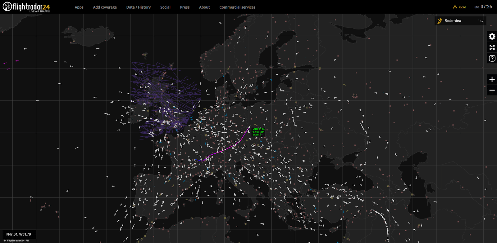
Pressing on the gear on the right you can access the map settings:
The paid account enables additional map options:
Additional setting options (for the paid account) include:
Track my airplane on FR24 – geography and airlines
Currently, the flight radar service tracks more than 32505 aircraft of different type arriving and departing from 8675 airports located in 190 countries. That makes for 960 airlines from all over the world embraced.
The current state of the Flightradar coverage is reflected by the airport icons in the area. With the sufficient coverage, the icons are blue. Still, the coverage and visibility of the plane depend on many parameters such as congestion, type of aircraft, its altitude, transponder type and operation, ground landscape and so on. It might happen that two aircraft at the same location are tracked differently. Not seeing the plane you need means it is either not covered by the service currently, or its transponder is out of service / non-compatible with the system.
What planes are tracked by the Live Flight Radar?
All the aircraft equipped with the ADS-B transponders are seen on the Flightradar24 map. However, currently, the large passenger aviation planes are the ones maintaining the technology. As well, the owners and operators of the smaller aircraft tend to equip them with the ADS-B transponders. Besides, even the ADS-B equipped aircraft might be not visible in the area with the limited number of ground ADS-B receivers or an uneven landscape.
Some of the aircraft (ADS-B equipped) that are usually tracked by the Flight Radar24 service, are listed below:
The next list consists of the aircraft not tracked by the service (mostly, not having the ADS-B transponder):
Some of the listed aircraft might be tracked via Flightradar24 if the ADS-B transponder has been installed. Otherwise, some of the planes from the first list might be not seen on the map due to the insufficient coverage or ADS-B transponder being out of operation.
Stats and archives – flyradar24 in numbers
The Flightradar24 gathers the statistics by the flights tracked. The number of flights tracked within the last 30 days, is shown on a diagram on the service’s website, having the daily number of the airplanes tracked as the reference points.
The free account allows getting the following data:
- number of aircraft tracked currently by the service. The actual models and the airplane modelling line are indicated.
- number of covered airlines. This information includes the airlines listed alphabetically (the letter-wise search is enabled), the international abbreviation for each airline and the number of the airplanes tracked. The search bar enables a quick search by the airline name.
- number of airports reflected. The airports are ranged by country. The list shows a country and the number of airports it hosts. There is also a search tool allowing tracking the airport by its name or the city it belongs to, as well as by IATA or ICAO codes.
Should you need more detailed information or the data for the longer period (e.g. 365 days), you might use the paid subscription that corresponds with your needs. Meanwhile, the specific request can be submitted via the website’s page for business, on the payment basis.
Fly radar free version – pros and cons
The basic functionality of the Flightradar 24 is available online for free. You will be able to track the aircraft and airports in real time, use the Search bar and its standard filters, change the basic map settings, browse the statistics up to 30 days and enjoy the 3D flight tracking (in the limited version), as well as some ads.
The paid account brings more diversity. It is provided for a year and can be Silver, Gold or Business. Each higher level account has the functionality of the lower level and additional functions.
With the Silver account, you will get:
The Gold account features the next benefits:
The Business account provides the widest functionality:
Making records with Flightradar
You can record your flight or any other tracked flight in online or Playback mode in the Flyradar service. For that, track airplane you need and hit the Playback button on the right. Adjust the settings (date, time, playback speed). Then, use the Javascript or a content recording prog to make a record. Start the playback and make full-screen size (for the better view). Upon finishing, save the video to your PC or a soft disc / memory pad.
Such videos can be shared on social networks, databanks, or video platforms like YouTube. There is a Flightradar24 channel on YouTube that makes a considerable video bank of similar records. Here, other videos of the flight records can be found, together with some teaching and entertainment videos.